Objective: Cycle from Marsden Railway Station up the Huddersfield Narrow Canal to the Standage Tunnel east portal. Cycle back past Marsden and down into Huddersfield. Continue past Aspley Basin along the Huddersfield Broad Canal to the junction with the Calder & Hebble Navigation. Head west, taking in the Salterhebble Branch, before finishing in Hebden Bridge. Take the train back to Marsden.
Trip Type: solo cycle
Distance: 28.6 miles
Time to complete: 3.5 hrs, 8.6 mph
Nicholson Guide: Guide 5, pp 49-52, 62-66, 202-203
Costs: free parking at Marsden. Train from Hebden Bridge to Marsden £8.60
Difficulty: fair
Adjacent Rides: Greenfield to Piccadilly, Hebden Bridge to Piccadilly, Cooper Bridge to ???
Note: technically (pedantically), Greenfield to Piccadilly is not an adjacent ride, as it starts from the western portal of Standage Tunnel. There are footpaths leading over the tunnel, the main one being Old Mount Road from Marsden, but it is a rough track only suitable for fit cyclists with mountain bikes – i.e. not the likes of me.
Overview
This is one of my top 3 rides. A lovely descent from the highest point of the Huddersfield Narrow (Standage Tunnel) into Huddersfield, followed by a ride along the Calder Valley, taking in the outskirts of Halifax and the towns of Brighouse, Sowerby Bridge and Mytholmroyd, before an excellent watering hole in Hebden Bridge to finish.
Despite significant expenditure, such as building the Sellers Yard Tunnel, the Huddersfield Narrow Canal is currently not navigable for much of its length, on either side of the Pennines, which is a great shame. There are several dry sections. However the other navigations on this ride can get busy with boats.
Although much of the ride is on excellent surfaces, there are short diversions along bumpy tracks, and an awkward set of steps to negotiate, so I’ve classified it as FAIR.
1. Marsden to Standage Tunnel (0.5 miles)
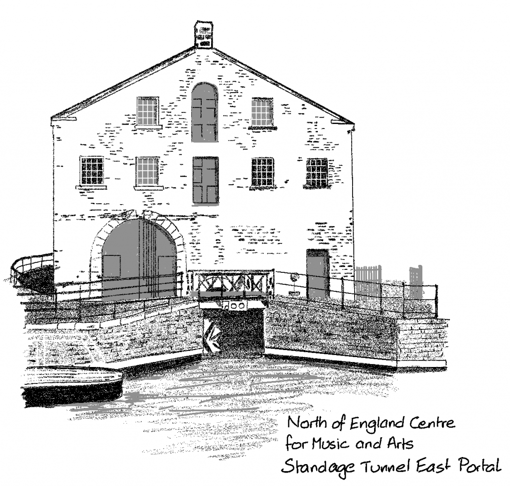
Park on Station Road, Marsden, HD7 6DH. This is a steep road but there will be space to park for free. Cycle (or more likely walk) up the hill to the towpath, which is before you get to the railway station. Turn left (west) towards the tunnel entrance (east portal). The tunnel is not open for navigation – only guided tour boats are permitted. There is a café and a number of interesting features around the tunnel entrance.
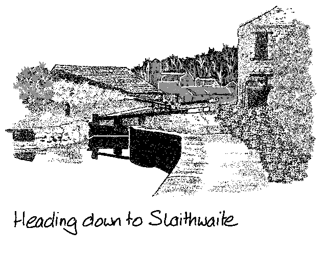
2. Standage Tunnel to Aspley Basin (9 miles)
The towpath is excellent, paved or gravelled and wide all the way down, with magnificent views over the countryside. It is popular with walkers in good weather, and so your progress may not be as fast as you’d like. There are a few cobbled sections at locks and bridge so be careful when it’s wet.
The towpath is closed at Mark Bottom Bridge (30) as of autumn 2024, probably for an extended time as there is an asbestos problem in a nearby factory. To get round the closure cross the bridge and immediately turn right along a path through a wood. This becomes a track called Millgate. This joins a road (Paddock Foot), go straight on and join Longroyd Lane, which runs parallel to the canal. At Manchester Road, A62, turn right over the canal bridge, then left before the river back onto the towpath (signposted).
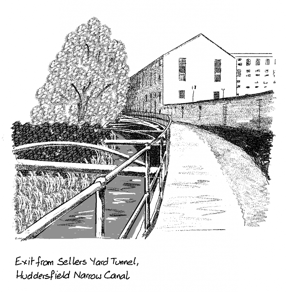
At Lock 3E, Sellers Lock, there is a tunnel and no towpath through. The Sellers Yard Tunnel was built recently, to reclaim the canal which had been concreted over some years before. Follow the signed pathway: turn right at Chapel Hill, A616, then immediately left on Colne Road, B6432, and left on Queen Street South. There are steps back down to the canal on your right, as it emerges from Sellers Yard Tunnel.
At Wakefield Road, A629, just before Aspley Basin take the ramp up to street level. Cross the road, turning right then left onto St. Andrews Road.
3. Aspley Basin to Cooper Bridge (3.5 miles)
Turn left into the Travelodge car park and the towpath is on the right. There is a decent surface all along the Huddersfield Broad Canal to Cooper Bridge junction.
At Fieldhouse Bridge (10) there are motorcycle gates, so take the path around.
At Cooper Bridge (1) the Huddersfield Broad joins the Calder & Hebble Navigation.
4. Cooper Bridge to Salterhebble (7 miles)
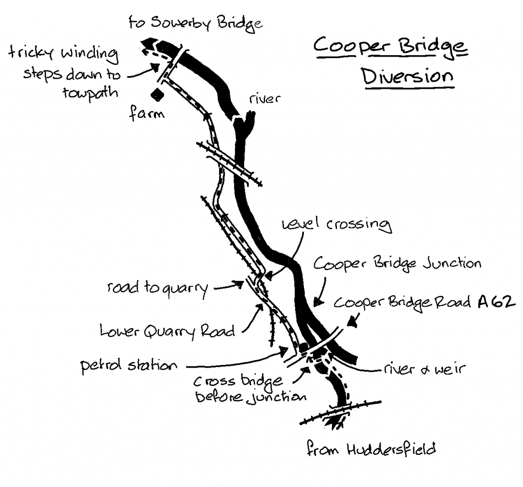
Cross Cooper Bridge to the road. Turn left and cross to the petrol station. Turn right on Lower Quarry Road. Continue for half a mile. After the railway bridge, but before the quarry entrance, take the track on the right. Cross the railway at the level crossing. Follow the track, which bends left then right then passes under another railway line. At the farm turn right to the canal. There are steep, winding steps down to the towpath which are tricky to carry your bike down.
After another half mile the canal rejoins the river. As the river bends to the right the towpath ends. Join River Street and continue to the end. Turn left on Calder Street, then right on Birds Royd Lane which continues to Huddersfield Road, A641, in Brighouse. Turn right and cross the river. Rejoin the towpath on the left by Sainsbury’s. You will pass (or maybe enter) the Mamil Café bar, ideally placed for cyclists.
Continue on the towpath, which is the Calder Valley Trail and an excellent surface, to Salterhebble Locks, which have steep slopes and can be slippery. At the top of the locks turn right on the Salterhebble Branch towards Halifax, which is only half a mile long. The basin at the end is a good place to munch your sandwiches.
If you are keen it is possible to cycle most of the way towards the centre of Halifax along the former continuation of the canal alongside Hebble Brook. Some stonework and bridges are still visible.
5. Salterhebble to Hebden Bridge (7.5 miles)
Return to the top of Salterhebble Locks and carry on west along the Calder & Hebble Navigation.
There is a short tunnel with a towpath through it (not marked as such in the Nicholson Guide).
At Sowerby Bridge the towpath goes to the left of the wharf then up a slope to Wharf Street. Go across the junction to Tuel Lane, and keep left past The Commercial Inn to rejoin the towpath at the impressive Tuel Lock (two locks knocked into one).
Luddenden Foot and Mytholmroyd are next, then on to Hebden Bridge, all on good quality canal towpaths, with no more river sections. Continue to Station Bridge (16). Either head straight to the station, or (my recommendation) ride the short distance down New Road, A646, to the Vocation & Co bar on the right just past the junction. A huge selection of fabulous cask and keg beers, and decent food too.
The station itself is spectacular, with ornate wooden signs and ironwork., immaculately maintained. Trains from Hebden Bridge back to Marsden are 1 per hour, changing at Mirfield. You will arrive at Platform 1 at Mirfield, and your connection will be on Platform 3, which is down to the road, under the bridge, and up the ramp to your left. You’ll probably have a significant wait here. It’s not the most exciting of places, but the Navigation Tavern is nearby, and open all day.
Arriving back at Marsden you will need to carry your bike up the steep steps to the road bridge which crosses the canal, then it’s a short distance downhill back to your car. Hope you put your handbrake on correctly.