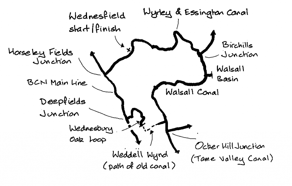
Objective: Park at Wednesfield, cycle round the Wyrley & Essington Canal, Wolverhampton Level Mainline, Wednesbury Oak Loop, and Walsall Canal, back to the start point.
Trip Type: solo cycle (circular ride)
Distance: 24 miles
Time to complete: 3 hrs, 9 mph
Nicholson Guide: Guide 2, pp 50, 51, 54, 58
Costs: free parking at Wednesfield. No trains involved as this is a circular ride.
Difficulty: fair (the one MODERATE section after Weddells Wynd can be avoided)
Adjacent Rides: Oldbury to Penkridge, Fazeley Junction to Gas Street Basin, Rushall Canal & Walsall
Overview
A circular ride with a good towpath all the way, with the exceptions of the path down the disused locks from Weddell Wynd to the Walsall Canal, and the final stretch: the Wyrley & Essington Canal from Birchills Junction to Wednesfield which is somewhat bumpy.
There are a number of radar gates, through which it would be difficult to manoeuver a heavy electric bike.

1. Wednesfield to Deepfields Junction (5 miles)
Park on Halecroft Avenue, Wednesfield, WV11 1TS, at the far end near the cadet hut to avoid blocking driveways. Cycle back to Lichfield Road, turn left and down to the canal bridge. Cross the bridge, on your right is a short footpath leading down to the towpath. Head west on the Wyrley & Essington. Continue to Horseley Fields Junction, which is close to Wolverhampton city centre.

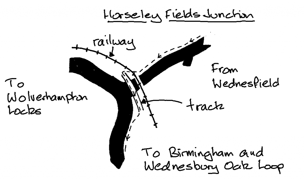
The junction is easy to miss if you go over (rather than under on the towpath) the bridge which immediately follows the railway bridge. You will end up going down the Wolverhampton Locks like I did, and if you reach the multi-storey car park that’s what you’ve done. Instead, as you head up to the level of the bridge which carries a track leading to a yard, turn left to cross the canal, drop down to the towpath and continue south on the Wolverhampton Level Mainline. Continue on the left side of the canal to Deepfields Junction, where the Wednesbury Oak Loop joins on the left.
2. Deepfields Junction to Moorcroft Junction (3 miles)
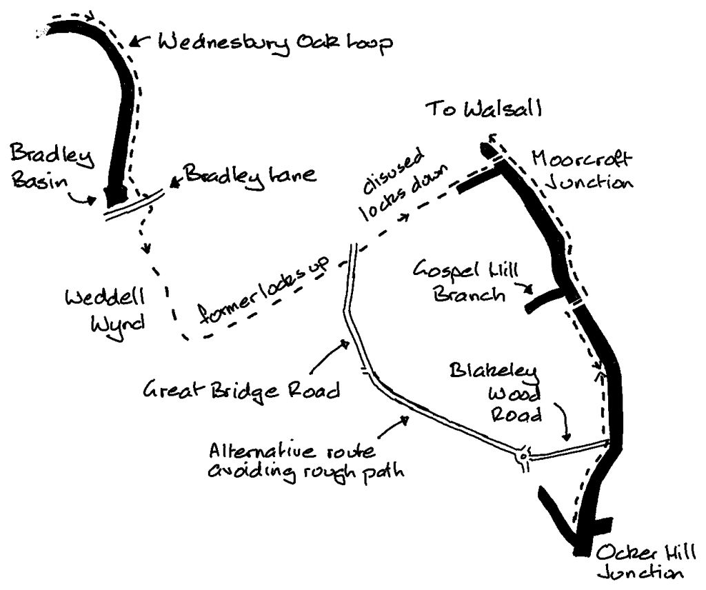
Turn left onto the Wednesbury Oak Loop, where the towpath continues on the left curving past suburban housing and parkland for a mile and a half. The canal ends at Bradley Basin, where there is a Canal & River Trust yard. Just before the basin the path deviates off to the left through a wood. Follow the path to emerge onto Bradley Lane.
Across the road and slightly to the left is a rough path leading to open parkland (Weddell Wynd). Join the cinder track leading uphill, keeping to the left as you climb. The hill is the site of the old locks, where once upon a time the canal continued to form a short cut through to the Walsall Canal.

At the corner turn sharp left and follow the straight track through to Great Bridge Road A4098. Cross over onto a narrow, rough, bumpy path, which leads down past disused locks taking you back to the level of the Walsall Canal at Moorcroft Junction. This is the former Bradley Arm, and there are moves to reopen the whole of this section of canal.
The bridge taking you across the Walsall Canal to the towpath also carries a large water main.
Note: if you want to avoid the rough section down the old locks turn right on Great Bridge Road down to the roundabout. Go straight across this onto Blakeley Wood Road, which takes you down to the canal close to Ocker Hill Junction. Turn right once you reach the towpath to get to the junction.
3. Moorcroft Junction to Ocker Hill Junction (3 miles)
If you want to join up with the adjacent ride (Fazeley Junction to Gas Street Basin) at the end of the Tame Valley Canal, turn right one over the water main bridge and head the mile and a half down to Ocker Hill Junction, the towpath changing sides just after the Gospel Oak Branch, which has no towpath. Once at the junction take a look at the view, have a Tunnock, then cycle back to Moorcroft Junction.
4. Moorcroft Junction to Wednesfield (9 miles)
Head north with the good quality towpath (complete with the occasional radar gate) on the right all the way up to where the canal widens and the Walsall Town Arm bends off to the right. Cross the footbridge to the left bank to tackle the 8 Walsall Locks, which are a bit of a climb. A further half mile and you arrive at Birchills Junction, the end of the Walsall Canal.
Bear left on the Wyrley & Essington. The towpath immediately becomes poorer, compacted earth and gravel, bumpy with tree roots in places, but still reasonable. You will pass Sneyd Junction and Holly Bank Basin, neither of which have towpaths so keep going. After 3 miles on the W&E you arrive back at Pinfold Bridge, where you first joined the towpath.
Double back after passing under the bridge, cross it and cycle up Lichfield Road, then right onto Halecroft Avenue and back to your car.
If you have time head for a pint at The Vine just a bit further up Lichfield Road, a Grade II listed heritage pub serving a good selection of Black Country beers, and decent scratchings.